
1934
If like me you love old maps of Liverpool then there are lots of links below you may find interesting, be aware though you may be absorbed for a few hours…. keep going to the end of the page, and enjoy!
Sadly, some may no longer work as web sites change/are deleted etc. Most of the maps are zoom-able for greater detail. Click for links. Updated regularly, so come back soon!
The maps will open in new windows… keeping going until the end of the page!
Various Maps 1664 to 1962
- Conjectural map of Liverpool in the 14th century
- 1664 – showing extent of original ‘Pool’ – with great additional info
- 1725 – Chadwick’s map of Liverpool
- 1765 – John Eyre’s map of Liverpool
- 1766 – R. Williamson
- 1776 – Very interesting map of Liverpool, the Mersey, and Wirral – zoom in
- 1785 – Charles Eye’s Plan of Liverpool
- 1790 – Liverpool – zoomable
- as above a great zoomable version
- 1796 – John Gore – A Plan of the Town of Liverpool
- 1803 – Richard Horwood – click on the individual maps, and then zoom in for great detail
- 1806 – A Plan of Liverpool with the Environs published Jan 1806 – Gregory
- 1807 – Roper & Cole, lovely map this – via Historic Liverpool
- 1816 – Title: “PLAN AND VIEW OF THE TOWN OF LIVERPOOL, 1816.” – by W. Faden
- 1817 – A superb zoomable map of Liverpool by John Gore
- 1818 – Map of the County Palatine of Lancaster from an actual survey made in the year 1818
- 1819 – as above, zoom in again

1819 – John Gore
- 1824 – William Swire. Alternative Link
- 1836 – The original map by Michael Alexander Gage – you will love the detail in this, including Kirkdale, Everton, Low Hill, Edge Hill, Toxteth – via the excellent Historic Liverpool
- 1836 – Liverpool – (based on above)
- 1836 – including the environs of Edge Hill & Toxteth Park, Kirkdale, Everton, Low Hill
- Liverpool and beyond, 1840-60 with fantastic overlay facility so you can compare with modern map
- 1844 – Plan of docks and warehouses proposed to be made at Birkenhead, in the County of Chester – includes Liverpool Docks, and ferry routes
- 1846 – brilliant plan of Liverpool Docks by Jesse Hartley
- 1848-50 Aintree; Ford; Litherland; Fazakerley; Netherton; Orrell; Sefton
- 1849 – another to zoom in and enjoy
- Surveyed: 1845 to 1846, Published: 1849 – Woolton to Halewood
- 1850 – Dingle
- 1851 – Ordnance Survey Map of North Liverpool
- 1851 – Liverpool, as above zoom in for great detail
- 1851 – additional images of key buildings in this colour, zoomable map: well worth viewing
- 1851 – Liverpool – as above but in black & white
- 1854 – Liverpool, by Henry Austen
- 1854-58 – Hilliar’s Guide to Liverpool – again zoom in
- 1860 – ‘Weekly Atlas’ Map of Liverpool – great detail in this one
- 1865 – Illustrated London News View of Liverpool from the Mersey
- 1872 – Liverpool & Birkenhead. Alternative link
- 1878 – Liverpool and Birkenhead
- 1883 – zoomable, Letts Son & Co. Alternative link
- 1885 – Bacon’s map of Liverpool
- 1885 – Birds Eye View of Liverpool – drawn by H.W. Brewer and W. Wylie from a hot air balloon
- 1888-1913 – Covers Liverpool and whole of the North West and beyond – great overlay feature (use the slider) Via: National Library of Scotland Mapping service
- 1889 – Plan of the Mersey Docks and Harbour Estate with part of the City of Liverpool, and Birkenhead – zoomable, great detail
- 1891 – Bacon’s New Plan of Liverpool
- 1894 – Liverpool
- 1888 – Goads Fire Insurance Maps of Liverpool. The detail in these is superb. Click on the individual maps to zoom in.

The above Insurance Maps now available via the excellent British Library tool – just zoom right in on Liverpool and click on location markers for very detailed maps. Also available with an overlay facility, and easier to use, via http://britishlibrary.georeferencer.com/compare#
- 1894 Hornby and Bramley Moore Dock area
- 1894 Woolton and Gateacre
- 1895 – Philips’ New Plan of Greater Liverpool – great detail!
- 1900 – Bacon’s plan of Liverpool: divided into 1/4 mile squares
- 1901 – zoomable
- 1910-19 – Plan of Liverpool: John Bartholomew – zoom in!
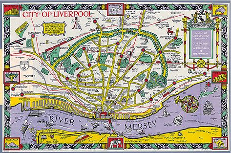
- 1934 – A Map of Merseyside, with Historical & Literary Allusions. Lovely map this, also see the cover
- 1948 – Liverpool Overhead Railway
- 1961 – UK wide – select an historical map on bottom right hand corner of screen
- 1962 – zoomable, another cracker!
- Old-maps.co.uk subscription required for full service, but you can still view the following for some great detail (you may have to zoom in/out) Sadly these have now been removed
Thanks for many of the above to the excellent Old Maps of Liverpool via Historic Liverpool – well worth a visit
Maps of Liverpool and its Environs: The County Series maps at scale 1:2500 for Liverpool and its environs, including Bootle, Wallasey, and Birkenhead 1874-1893 – British History Online
- Orrell
- Fazakerley
- Wellington to Canada Docks
- Canada to Hornby Docks
- Bootle and Walton
- Walton Hall Park
- Norris Green
- Kirkdale and Everton
- Anfield, Clubmoor, Tuebrook
- West Derby
- L3 Scotland Road
- Fairfield
- Broadgreen, Knotty Ash, Old Swan
- Liverpool Central
- Edge Hill and Wavertree
- Wavertree, Childwall
- Toxteth
- Dingle and Sefton Park
- Smithdown Road to Calderstones
- Otterspool
- Aigburth, Allerton, Calderstones, Mossley Hill
- Garston, Grassendale
Liverpool and Beyond: Superb individual large scale maps
Surveyed: 1890, Published: 1891
(click on a box, then see maps right) – LINK

The detail in these includes building names/uses
ORDNANCE SURVEY 25-inch Zoomable Maps – great details in these from National Library Scotland – various dates.
- Aigburth to Cressington Park 1925 – 28:
- Aigburth to Cressington Park 1938 – 46:
- Anfield 1890 – 93:
- Anfield 1906 – 08:
- Anfield 1925 – 27:
- Aintree – Kirkby 1908
- Aintree – Revised: 1907, Published: 1908
- Allerton 1937 – 39
- Bootle 1890 – 93:
- Bootle 1890 – 94:
- Bootle 1906 – 08:
- Bootle and Kirkdale 1909
- Bootle 1924 – 27:
- Bootle 1938 – 45:
- Broadgreen – Dovecot: Revised: 1925, Published: 1927
- Coburg Dock to Otterspool 1846 – 48:
- Croxteth Park – Knowsley 1905 – 09
- Croxteth Park: Revised: 1906, Published: 1908
- Dingle to Otterspool 1924 – 27:
- Dingle to Otterspool 1938 – 45:
- Edge Hill/Wavertree 1905 – 08:
- Edge Hill/Wavertree 1924 – 27:
- Edge Hill/Wavertree/Old Swan 1925-33
- Edge Hill/Wavertree 1938 – 46:
- Kensington 1905 – 08:
- Kensington 1925 – 27:
- Kirkdale and Everton 1890 – 93:
- Kirkdale and Everton 1906 – 08:
- Kirkdale and Everton 1924 – 27:
- Knotty Ash-Stockbridge Village: Revised: 1906, Published: 1908
- Fazakerley 1889 – 93:
- Fazakerley/Kirkby – Revised: 1906, Published: 1908
- Fazakerley 1925 – 27:
- Fazakerley, Aintree, Kirkby 1925-28
- Garston 1889 – 91:
- Garston -Surveyed: 1888 to 1890, Published: 1893
- Garston 1905 – 07
- Garson 1924 – 25:
- Garston 1937 – 39:
- Grassendale/Garston: Surveyed: 1888 to 1891, Published: 1894
- Herculaneum Dock/Dingle 1924 – 27:
- Huyton with Roby, Page Moss 1937 – 39:
- Litherland, Orrell 1889 – 91:
- Litherland, Orrell 1939 – 47:
- Liverpool Central 1890 – 93:
- Liverpool Central 1906 – 08:
- Liverpool Central 1924 – 27:
- Liverpool City Centre 1924 – 28
- Liverpool Central 1936 – 48: (inc. Birkenhead)
- Melling – Revised: 1925, Published: 1927
- Mossley Hill/Allerton 1890 – 93:
- Mossley Hill/Allerton 1937 – 39:
- Old Swan 1890 – 93:
- Old Swan 1925 – 27:
- Old Swan 1937 – 39:
- Otterspool to Garston 1904 – 05:
- Princes Park to Aigburth 1889 – 91:
- Princes Park to Aigburth 1905 – 09:
- Prince Park to Aigburth 1924 – 25:
- Princes and Sefton Park 1924 – 27:
- Princes and Sefton Park 1938 – 45:
- Scotland Road – Surveyed: 1890, Published: 1891.
- Scotland Road 1924 – 27:
- Seaforth 1889 – 93:
- Seaforth 1907 – 08:
- Seaforth 1937 – 39:
- Smithdown to Calderstones to Childwall 1937-39
- Sefton Park and Calderstones 1938 – 46 (OS 6-inch)
- South Docks and Toxteth 1889 – 1893:
- South Docks and Toxteth 1924 – 27:
- Toxteth Park – Revised: 1905, Published: 1908
- Vauxhall/Scotland Road 1906 – 08:
- Vauxhall 1924 – 27:
- Walton Park 1890 – 93:
- Walton Park 1906 – 08:
- Walton Park 1924 – 27:
- Walton Vale – Warbreck Moor – Revised: 1925, Published: 1927
- Warbreck Moor – Aintree – Revised: 1925, Published: 1927
- Waterloo/Seaforth – Surveyed: 1889 to 1891, Published: 1893
- Waterloo/Seaforth -Revised: 1925, Published: 1927
- Waterloo/Seaforth – Revised: 1937, Published: 1939
- West Derby 1925 – 27:
- West Derby inc. Anfield 1925 – 28:
- West Derby inc. Anfield 1938 – 47:
- Woolton 1891 – 93:
- Woolton 1904 – 07:
- Woolton 1925 – 27:
- Woolton 1936 – 37:
- Woolton & Gateacre 1904-08
Now this is a fantastic facility, hosted by National Library of Scotland, which allows you to overlay historic maps with a modern map. Takes a little getting used to but very useful: I find the OS 25 Inch, 1892-1914 map to be the most useful: Link

Overlay the old map on the current
Another great overlay tool, this one from British Library:
You can quickly create an overlay of historic maps on current mapping and compare the past with the present – Link
- 1956 – 1973: More useful maps from NLS, this time covering 1956 – 1973. Click on the ‘As individual sheets….’ and then zoom into Liverpool
Another fantastic series of maps covering both Liverpool and the Wirral over the period 1950 – 1968, and again from the invaluable National Library of Scotland.
- Bootle to Liverpool Centre, inc. Wallasey – 1949 to 1955, Published: 1956 View map: SJ39SW – A (includes: Birkenhead St Mary; Bootle cum Linacre; Liverpool; Wallase… – Ordnance Survey National Grid Maps, 1940s-1970 (nls.uk)
- Bootle to Liverpool Centre, inc. Wallasey -1952 to 1966, Published: 1967 View map: SJ39SW – A (includes: Birkenhead St Mary; Bootle cum Linacre; Liverpool; Wallase… – Ordnance Survey National Grid Maps, 1940s-1970 (nls.uk)
- Liverpool Central to Old Swan, and Norris Green – 1948 to 1955, Published: 1957 View map: SJ39SE – A (includes: Bootle cum Linacre; Liverpool) – Ordnance Survey National Grid Maps, 1940s-1970 (nls.uk)
- Kirkdale and Everton, to Old Swan, and Norris Green – 1949 to 1968, Published: 1968 View map: SJ39SE – B (includes: Bootle cum Linacre; Liverpool) – Ordnance Survey National Grid Maps, 1940s-1970 (nls.uk)
- Crosby to Bootle 1954 to 1964, Published: 1965 View map: SJ39NW – A (includes: Bootle cum Linacre; Ford; Great Crosby; Litherland; Orrell… – Ordnance Survey National Grid Maps, 1940s-1970 (nls.uk)
- Orrell Park to Aintree – Pre-1930 to 1955, Published: 1956 View map: SJ39NE – A/ (includes: Aintree; Bootle cum Linacre; Kirkby; Litherland; Liverpoo… – Ordnance Survey National Grid Maps, 1940s-1970 (nls.uk)
- Toxteth to Wavertree, and Grassendale: Surveyed / Revised: 1950 to 1955, Published: 1956 View Map
- Toxteth to Wavertree, Mossley Hill, and Grassendale 1950 to 1967, Published: 1967 View map: SJ38NE – B (includes: Bebington and Bromborough; Liverpool) – Ordnance Survey National Grid Maps, 1940s-1970 (nls.uk)
- South Docks Liverpool, and Wallasey – 1952 to 1963, Published: 1966 View map: SJ38NW – B (includes: Bebington and Bromborough; Birkenhead St Mary; Liverpool; … – Ordnance Survey National Grid Maps, 1940s-1970 (nls.uk)
- Calderstones, Childwall, Gateacre – 1950 to 1967, Published: 1967 View map: SJ48NW – A (includes: Halewood; Huyton with Roby; Liverpool; Tarbock) – Ordnance Survey National Grid Maps, 1940s-1970 (nls.uk)
- Broadgreen, Croxteth Park, Huyton – 1950 to 1963, Published: 1965 View map: SJ49SW – A (includes: Huyton with Roby; Knowsley; Liverpool) – Ordnance Survey National Grid Maps, 1940s-1970 (nls.uk)
1942 – Seven fascinating reconnaissance Nazi German Supreme Command maps showing bombing targets in the city: hover over pic for title, click number for link:


- 1950’s – Modern Day: Searchable Overlay map
Another great piece of work from Historic-Liverpool which allows you to search for old Liverpool streets by name and see them overlaid onto a modern map – really useful if a street has since disappeared – LINK
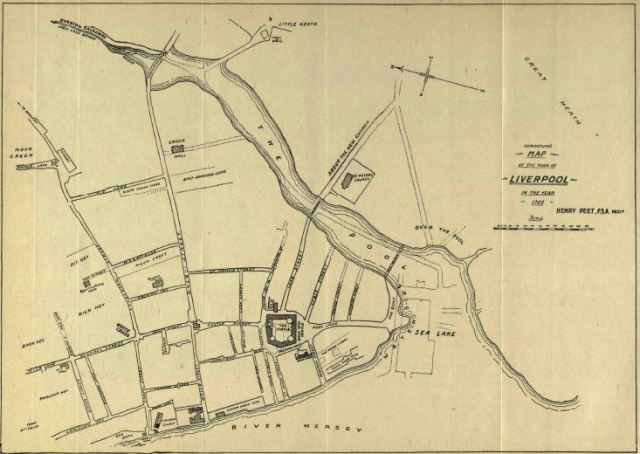
- A couple of intriguing maps are to be found in this document: ‘Liverpool in the Reign of Queen Anne, 1705 and 1708’ – link
…….so hard to imagine the ‘pool’ running up Paradise St and Liverpool One today!
The first is of 1705 showing the street plan and outline of the intended dock:
 The second, produced later, shows a ‘Plan of the Site of the Ancient Pool of Liverpool as disposed of under Leases from the Corporation between the years 1672 and 1730’

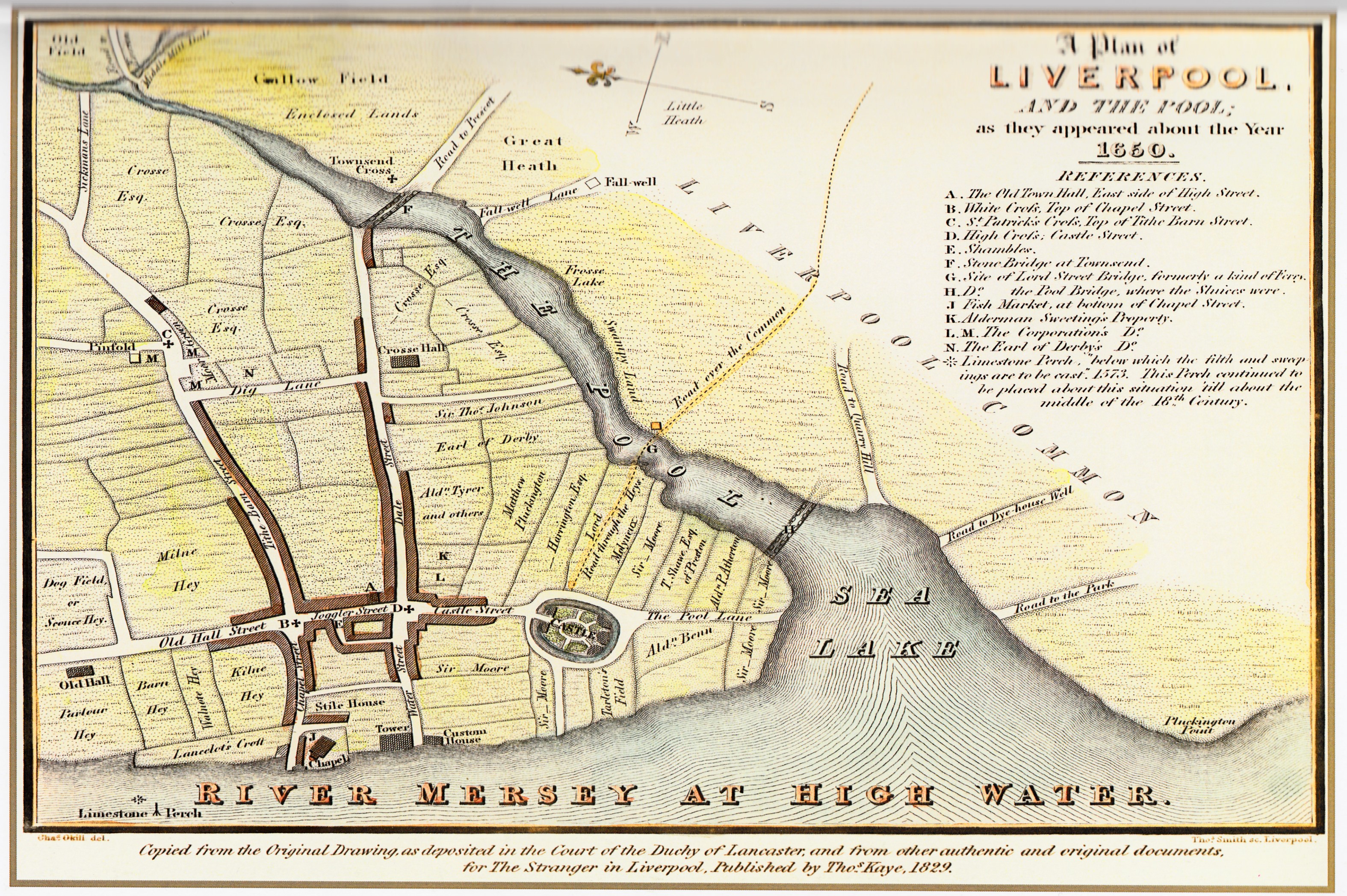
- 1650

1650 – click
- 1725 – a plan showing the Townfield of Liverpool about 1725

1725 – click
- 1770 – “The South-East Prospect of LEVERPOOL, taken from Seacombe Boat-house”
These are fantastic images which you can zoom into for great detail

1770 by George Perry
1770 – “A VIEW of the TOWN and HARBOUR of LEVERPOOL” – Link

1770 – by George Perry
- 1824 – William Swire’s Plan of Liverpool (click map for zoomable version)

- 1847 – Ackermann’s Panoramic view of Liverpool
Another great zoom-able resource via Historic Liverpool that gives a whole new perspective! – LINK

- 1854 – Map of the borough of Liverpool: with Parliamentary boundaries, ecclesiastical divisions and a part of the Cheshire coast – LINK

1854 – click above LINK for zoomable version
- Liverpool, 1859, part of Birkenhead, the docks, and Cheshire coast – LINK

Click LINK above to zoom in for great detail
- Bird’s-eye view of Liverpool as seen from a balloon 1885 / drawn by H.W. Brewer and W. Wylie – LINK
If you struggle to spot what is what see the key below the pic:

Click LINK above to zoom into detail

Key to the above
- If you are interested in buying maps of old Liverpool I can definitely recommend Alan Godfrey Maps on-line where you will find a great selection:
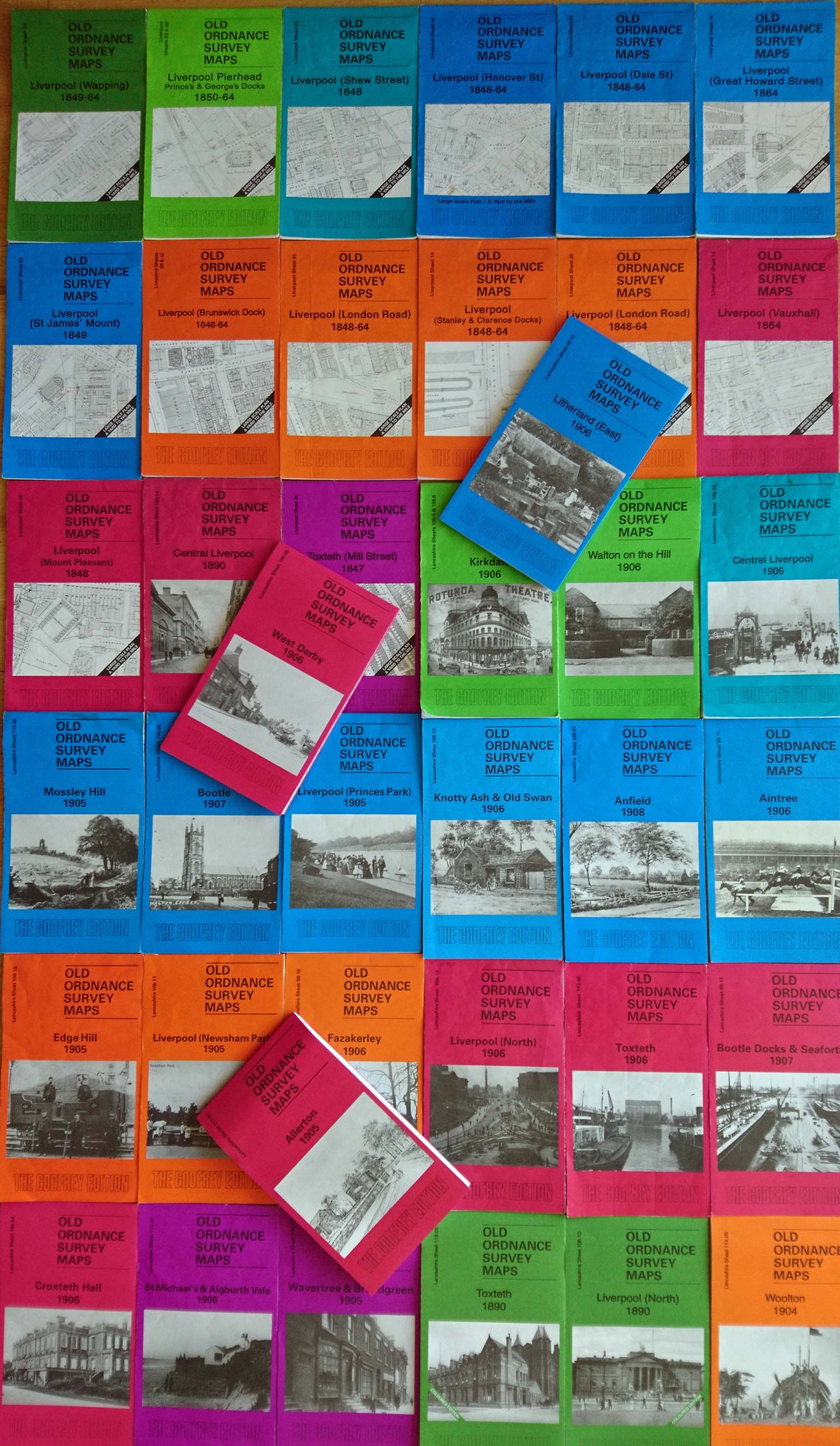
A selection of maps available at Alan Godfrey
Liverpool – 1650 Click to zoom into detail

1796 – zoom in for detail

1852

1859
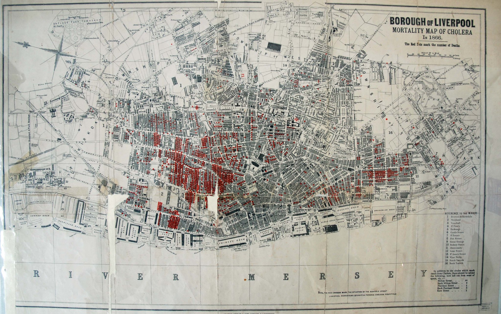
1866 – Cholera hit areas
1928 (click pics to enlarge)


Central Liverpool 1939

The density of Kirkdale and Everton c1960

Liverpool & Merseyside Industrial Map – 1948
- ‘Maps and Plans of Liverpool and District by the Eyes family of Surveyors’
An interesting read this one: https://www.hslc.org.uk/wp-content/uploads/2017/06/62-7-Stewart-Brown.pdf
- Maps and related resources – Liverpool through the centuries
Another excellent resource for maps and more put together by @vrsimility – LINK
